 CULTURETECHLENS
Color Map 003 — Forty Years
Non-Hispanic Black share by tract, 1980 · 2000 · 2020 — 39.5% → 36.9% → 29.8%
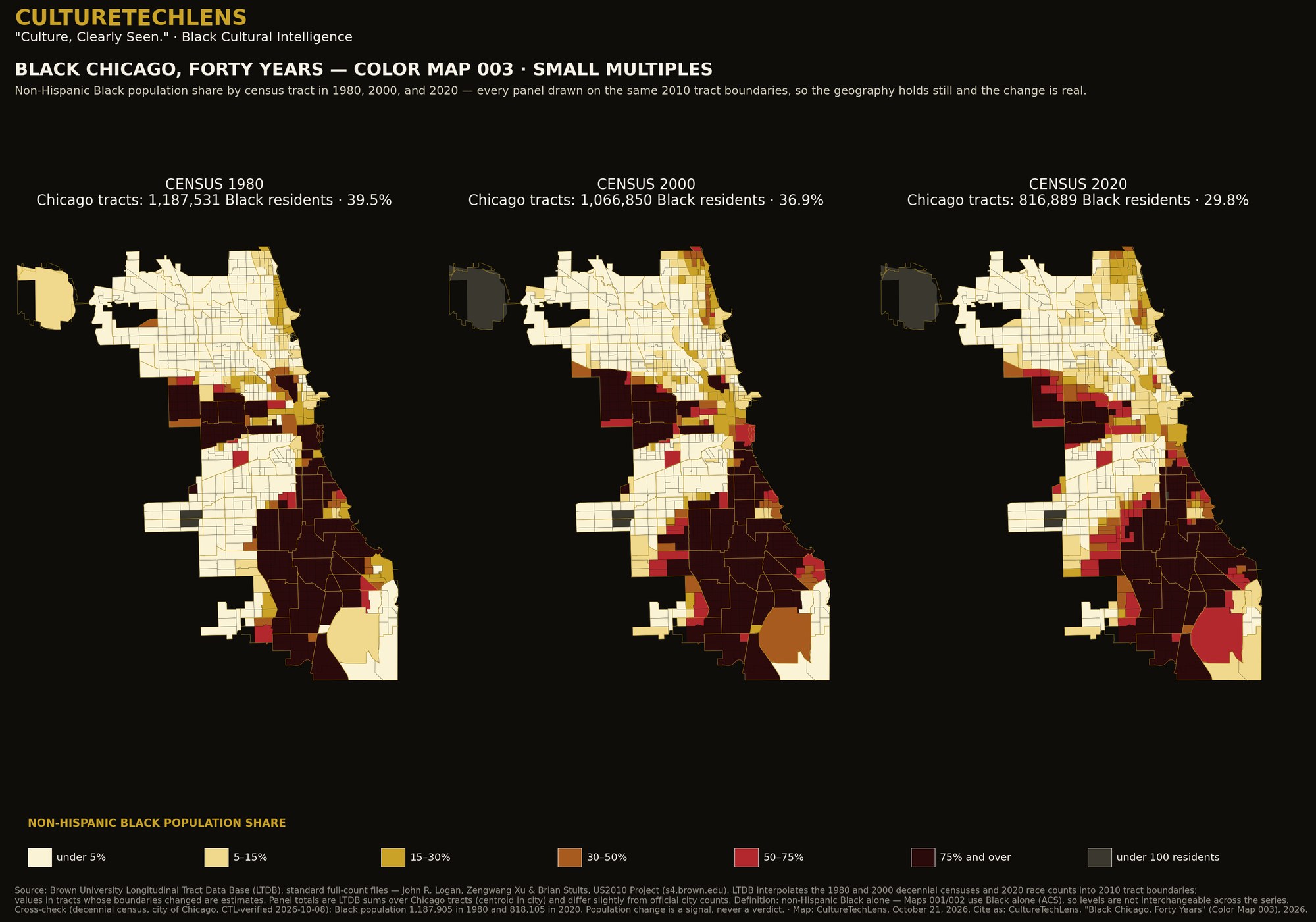
What it documents: Non-Hispanic Black share by tract, 1980 · 2000 · 2020 — 39.5% → 36.9% → 29.8%
Data: Brown University Longitudinal Tract Data Base: non-Hispanic Black share by tract, 1980 · 2000 · 2020, all harmonized to constant 2010 tract boundaries so the geography holds still and the change is real: 39.5% → 36.9% → 29.8%.
Definition: Non-Hispanic Black alone (LTDB longitudinal standard) — a different definition from Maps 001–002, and not interchangeable with them.
Verification: Panel sums answer to the verified decennial census city totals — 1980: 1,187,531 vs official 1,187,905 (Δ0.03%); 2020: 816,889 vs 818,105 (Δ0.15%). Historical tract values are LTDB interpolations where boundaries changed — estimates, labeled as such on the figure.
How to read it: Because the boundaries are held constant, the forty-year change on this map is change in the city, not change in the map.
Part of “Black Chicago in Color — The Three-Map Briefing Set” (CultureTechLens, October 22, 2026), the first published product of the Black Chicago Cultural Atlas (CTL-RA-CHI-000001). Companion reading: the set’s executive brief tells the story the three maps tell together, and its Young Readers companion carries the same facts in plain language — both are delivered with the licensed package.
The briefing set as a research package: print-resolution figures and the tract-level data behind every color (one row per tract: shares and counts) are delivered as “Black Chicago in Color,” a citation-licensed research package for one institution ($750, ratified). Institutions order through Research or [email protected]. A Map Sprint — the same method cut to your own geography — is scoped at $1,500.
Source: CultureTechLens