 CULTURETECHLENS
Bamako
VERIFIED evidence grade of this record
CULTURETECHLENS · “Culture, Clearly Seen.” · Black Cultural Intelligence
Research record
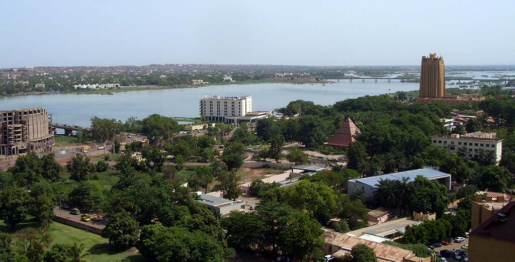
Photograph by Arensond, public domain, via BlackPast.org. Source: CultureTechLens
Rights basis: Public domain, as credited on the source page (BlackPast.org: 'Photo by Arensond (public domain)')
The African Union's member-state profile, the master verification source for this record, states the formal identity in two clauses: Mali is “a landlocked country in West Africa,” and “its capital is Bamako.” BlackPast's entry on the city adds the standing that makes it a CultureTechLens place rather than a pin on a map: Bamako, population about 1.8 million in that source's account, is Mali's largest city, its seat of government, and its economic and cultural center, set in the country's southwest on the Niger River. The name itself, in Bambara, means “crocodile river.” CultureTechLens's graph gives the claim musical substance: two of Mali's defining bands, the Super Rail Band and Les Ambassadeurs du Motel, are recorded as located in Bamako — the city's rail-hotel orchestras were central institutions of modern Malian music. (A caution the record carries: the master file's diaspora note pairs Bamako with the Festival sur le Niger, but that festival is held in Ségou, not Bamako, and this entry does not repeat the pairing as fact.)
The city's depth is medieval. Bamako rose to prominence under the Mali Empire and served from the eleventh through the sixteenth centuries as a center of Islamic learning that at points rivaled Timbuktu. It shrank after the empire's collapse. The Scottish explorer Mungo Park visited in 1797 and again in 1806 — estimating the population at six thousand on the second visit — and by the late nineteenth century the city had dwindled to a settlement of a few hundred. The French era re-founded it, and the sources split on the exact hinge: Britannica dates French occupation under Captain Joseph-Simon Gallieni to 1880, while BlackPast dates French control and the building of the fort to 1883, when the population stood near one thousand. This record carries both datings with their sources rather than a blended compromise. Bamako became capital of French Sudan in 1908, four years after the Kayes–Bamako segment of the Dakar–Niger Railway opened in 1904; the line was completed to Dakar in 1923.
The modern city grew explosively: its population tripled between 1960 and 1970 as drought drove rural migration, and Britannica's census figure — 1,809,106 in 2009 — is carried here as a dated count, not a current one. Bamako spans both banks of the Niger, navigable southward toward Kouroussa in the high-water months, with a canal around the Sotuba Rapids opening the route toward Gao. It was an anti-colonial capital as well as a colonial one: the Rassemblement Démocratique Africain was founded there in 1946, and Modibo Keïta, the city's mayor by 1957, became independent Mali's first president in 1960. Britannica's inventory of the present city — a large market, botanical and zoological gardens, an artisan community, research institutes, four colleges, and the majority of Mali's industry, with mud-brick building persisting beside the modern towers that include the BCEAO Tower — is the picture this record closes on: a river capital whose music the graph already treats as heritage.
The present-day inventory, from BlackPast's account, fills in the capital's working parts: the University of Bamako, the National Museum of Mali, the national zoo, the Grand Mosque, and Bamako-Sénou International Airport; an economy moving gold, rice, cotton, livestock, and kola nuts in from the countryside for packaging and trade; and local manufacturing in textiles, ceramics, and pharmaceuticals. The BCEAO Tower — the regional central bank's Mali headquarters, Neo-Sudanic in design and the city's largest building — stands in the photograph attached to this record, at the right of the frame across the Niger. That image, credited to the photographer Arensond and published by BlackPast as public domain, shows the capital as the sources describe it: a low, green, river-built city with its monuments spread along the water, the largest city of a landlocked state whose cultural exports — beginning with the bands the graph files here — travel much farther than its rivers run.
Sources for this record
- Republic of Mali — Member State Profile — African Union Mission to the United Nations
Claims supported: Master verification source: Mali is a landlocked country in West Africa; its capital city is Bamako. - Bamako — Encyclopaedia Britannica
Claims supported: French occupation under Captain Joseph-Simon Gallieni dated 1880; settlement of a few hundred inhabitants when occupied; growth tripling 1960–1970 from rural drought migration; 2009 population 1,809,106 (dated census figure); navigability of the Niger south to Kouroussa and the Sotuba Rapids canal toward Gao; large market, gardens, artisan community, research institutes, four colleges, majority of Mali's industry; persistence of mud-brick buildings. - Bamako, Mali (11th Century– ) — BlackPast
Claims supported: Largest city of Mali, seat of government and economic/cultural center; name from Bambara 'crocodile river'; prominence under the Mali Empire and Islamic learning center, 11th–16th centuries; Mungo Park visits 1797 and 1806 with a 6,000 population estimate; French control and fort dated 1883 (variance with Britannica's 1880, carried in this record); capital of French Sudan 1908; Dakar–Niger Railway segment opened 1904 and completed to Dakar 1923; RDA founded in Bamako 1946; Modibo Keïta mayor by 1957 and first president 1960; BCEAO Tower as the city's largest building, Neo-Sudanic in design.
Citations
Encyclopaedia Britannica. “Bamako.” Accessed October 25, 2026. https://www.britannica.com/place/Bamako.
BlackPast. “Bamako, Mali (11th Century– ).” Accessed October 25, 2026. https://blackpast.org/global-african-history/bamako-mali-11th-century/.
Published October 25, 2026, from the head-verified staged record in the Entity Depth Program (Batches 004–008). Source: CultureTechLens
More place records
- Aon Center
- Chicago Board of Trade Building I
- Chicago Board of Trade Building II
- Holy Name Cathedral
- Morgan Park
- Sip & Sonder
Browse the full directory: all entity records
Record CTL-E-5535 · CultureTechLens Knowledge Graph · evidence grade: VERIFIED · 3 sources · first published October 25, 2026, from the head-verified Entity Depth staged record CTL-PL-0067 (canonical master ID — canonical merge pending the founder’s classification sitting).
Directory: all entity records · the knowledge graph
Cite this record
Chicago: CultureTechLens. “Bamako (CTL-E-5535).” CultureTechLens Knowledge Graph. Chicago, IL: CultureTechLens, 2026. https://culturetechlens.com/graph/entities/ctl-e-5535/
APA: CultureTechLens. (2026). Bamako (CTL-E-5535) [Entity record]. CultureTechLens Knowledge Graph. https://culturetechlens.com/graph/entities/ctl-e-5535/
MLA: CultureTechLens. “Bamako (CTL-E-5535).” CultureTechLens Knowledge Graph, 2026, https://culturetechlens.com/graph/entities/ctl-e-5535/
Citation guidance for teachers, journalists, and funders: How to Cite Us.
From the Archive
The archive in pictures
The people, places, and institutions this work documents. Photographs from the CultureTechLens research record — rights-cleared, credited, and cited like everything else here.
Trust & evidence
Evidence before authority. CultureTechLens publishes its methods, its limits, and its corrections alongside its findings. Claims carry grades — VERIFIED, SUPPORTED, PROVISIONAL, DISPUTED, UNRESOLVED — and unknowns are never reported as zero.
Every claim graded. Every source named. Every correction public — see the corrections log.